Before 1885: the Whiskey Gap trail
A gap through the Milk River Ridge offered a passage across the border country long before the railway settlement. Dale Speirs describes it as a travel route used by Indigenous people and later by whiskey traders. His postal history connects the name Whiskey Gap with that trade and places the trading-post era before organized homesteading in the 1890s. Speirs, “Whiskey Trader Post Offices,” Journal of Alberta Postal History 12, April 2017, p. 13
The name Whiskey Gap belonged to a travel route before it belonged to a railway settlement. In Historic Sites of Alberta, historian Hugh A. Dempsey recorded Vern Shaw’s recollection of an abandoned trading post on the St. Mary River. Shaw, who settled in the Cardston district in 1885, identified it as a former post of Abe Farwell and a stopping place on the route between Benton and Fort Whoop-Up. The old Whiskey Gap trail passed the post. Shaw remembered its log building and large stone fireplace, surviving after the business had closed. His account places the name within the nineteenth-century trading landscape, decades before Fareham acquired its post office. Hugh A. Dempsey, Historic Sites of Alberta, sixth printing, 1963, p. 34
1918–1925: Fareham’s ranch-house post office
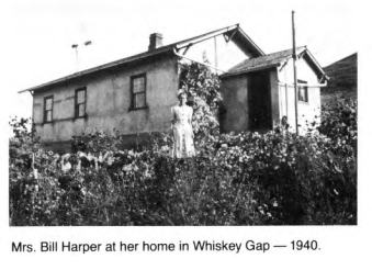
The Fareham post office opened on March 1, 1918, in James H. Faulkner’s ranch house. Faulkner chose the name of his ancestral English home. His appointment ended on April 8, and the office moved to his brother-in-law William P. Harper’s ranch. Harper remained postmaster until September 2, 1925; his wife Esther performed the postal work. Two further postmasters followed before the office acquired premises in the developing commercial settlement. Dale Speirs, “Whiskey Trader Post Offices,” Journal of Alberta Postal History 12, April 2017, p. 13
1925: the Boundary Baseball League is formed
A meeting at Whiskey Gap established the Boundary Baseball League in 1925, according to C. Graveland’s history. Schoolteacher Everett Hedley helped bring players together from the surrounding districts. The seven founding teams were Del Bonita, Rinard, Taylorville, Jefferson, Kimball, Aetna and Woolford. C. Graveland, Heritage of the High Country, p. 175 · The teams and early baseball photographs
1929: businesses gather at the new railway terminal
Commercial development was already under way in the spring of 1929. On April 25, the Cardston News reported that Woolford Mercantile had purchased six lots from W. P. Harper through the Cardston Investment Company. Its plans included a store opposite the station, an implement warehouse and a lumber yard. Houie Gum, a Chinese restaurant keeper, purchased an adjoining lot. The newspaper identified the townsite as Fareham, with Whiskey Gap in parentheses. Cardston News, April 25, 1929, p. 1, “Fareham Station News”
The Lethbridge Herald independently reported the land purchases on May 2. Its Woolford correspondent described Gum as the local restaurant keeper and anticipated that Fareham would grow into a prosperous village. By June 13, the Cardston News was reporting his move to his restaurant at the Fareham terminal. The reports show businesses following the new railway toward its endpoint, with merchants from Woolford establishing premises in the emerging settlement. Lethbridge Herald, May 2, 1929, p. 5; Cardston News, June 13, 1929, p. 2
The community history recalls Huey Gum’s restaurant, hotel and pool hall being built in 1929. Milk and cream from Otto Sommerfeldt supplied a Sunday treat: ice cream made at the restaurant. Heritage of the High Country, p. 45 · Huey Gum’s restaurant and its history
The Woolford–Whiskey Gap extension began operating in 1929. It completed a 21-mile subdivision from Raley through Woolford to Whiskey Gap. On September 19, 1929, the Lethbridge Herald announced the first train leaving Lethbridge that day over the extension to Fareham. Grain Handling and Transportation Commission, Grain and Rail in Western Canada, 1977, p. 477 · Lethbridge Herald, September 19, 1929, p. 11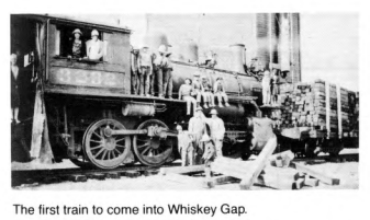
1930–1931: the post office becomes Whiskey Gap
Alvin Edward Knight became postmaster on January 15, 1930, and moved the office into his general store. He applied to change its name. The postal change from Fareham to Whiskey Gap took effect on July 1, 1931. Speirs, pp. 13–14
About 1933–1934: Whiskey Gap fields a baseball team
Graveland’s account dates Whiskey Gap’s own team to about 1933–1934. It played for a few years before a shortage of players brought it to an end. C. Graveland, Heritage of the High Country, p. 175
Mid-1930s: the customs office
The community history records that Whiskey Gap’s customs office became permanent in 1934. A house later moved from Woolford provided both an office and a home for customs officer J. R. Gresham and his family. Heritage of the High Country, p. 201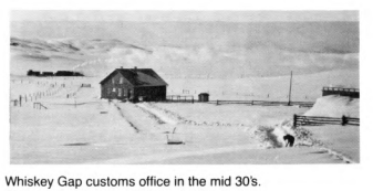
1937–1938: a service point for the surrounding district
Whiskey Gap’s railway served work beyond the townsite. On March 9, 1937, the Lethbridge Herald reported that a liner for the Sunshine Oil well at Del Bonita was travelling from Okotoks to Whiskey Gap by rail. A truck would carry it from the railhead to the lease. The well was awaiting the equipment before further production testing. This journey connected the branch railway with the oil exploration then taking place around Del Bonita. Lethbridge Herald, March 9, 1937, p. 1, “Await Liner”
Knight left the postmastership on March 14, 1938, sold his store and moved his family to central Alberta, where he entered the petroleum business. Speirs, p. 14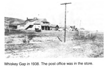
1939: Huey Gum’s pool hall changes hands
The Secretan family account records that Charles Secretan bought the pool hall from Huey Gum in 1939 and continued operating it. Heritage of the High Country, p. 503 · Huey Gum and the inn
1939: the border crossing shifts to Del Bonita
The Whiskey Gap road crossing closed when the Del Bonita crossing opened in 1939. The new route connected the Alberta side with Del Bonita, Montana, at the international boundary. Crossing history · Del Bonita border crossing
1940: Mrs. Bill Harper at home
1940–1978: Secretan and Train at the station
Galt Museum & Archives identifies the two men as Duel (J. J.) Secretan and Scotty Train, standing outside the Canadian Pacific Railway station at Whiskey Gap. Its catalogue gives a date range of 1940–1978 and describes the photograph as circa 1978. Three grain elevators stand behind the station.
The same photograph appears in Heritage of the High Country, p. 46, whose caption names Duel Secretan and Scotty Train. The book supplies no photograph date. Book source
The original photograph belonged to Robert and Olive Train of Magrath. Galt lists the Del Bonita Historical Society as its acquisition source. Galt catalogue, accession 19841071037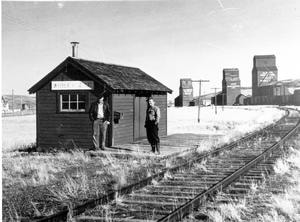
The larger Prairie Towns copy
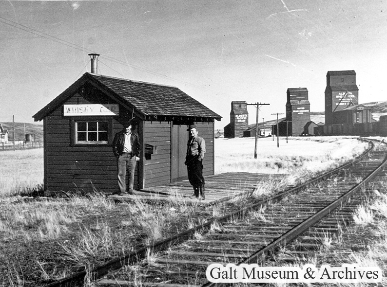
Prairie Towns captions this copy 1929; Galt’s catalogue dates the same scene 1940–1978, with “circa 1978” in its description. Both downloaded versions and their source descriptions are retained. Prairie Towns source page · Galt original download · Prairie Towns original download
1944–1951: commerce beyond the railway boom
A February 2, 1944, classified advertisement offers a small glimpse of local business equipment. C. L. Secretan of Whiskey Gap advertised two pool tables, thirty cues and three sets of balls. The advertisement identifies the seller and the equipment, without naming the establishment in which they had been used. Lethbridge Herald, February 2, 1944, p. 12
Whiskey Gap also appeared in the regional auction circuit. An advertisement published on November 3, 1951, listed a November 6 sale there for the Community Auction Sales Association Ltd., whose head office was in Pincher Creek. Otto Sommerfeldt of Whiskey Gap was named as a director. Other advertised sale points included Cardston, Claresholm, Pincher Creek and Pakowki. Lethbridge Herald, November 3, 1951, p. 16
1961–1967: a film title and the end of postal service
In 1961, Colin Low directed the National Film Board’s The Days of Whisky Gap. The documentary used photographs and artists’ drawings to recount the early history of the North-West Mounted Police. Its title carried the place name into Canadian documentary film, although its subject extended across the western prairies. National Film Board, film catalogue; NFB remembrance of Colin Low, February 25, 2016
The Whiskey Gap post office closed on September 15, 1967, because no suitable replacement postmaster was available. Twelve postmasters had followed Knight. Postal service thereafter came through a rural route from Cardston. Speirs, p. 15
1974: Tom Willock photographs the grain elevators
1976: a location for Days of Heaven
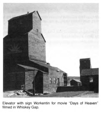
Whiskey Gap was among the Alberta locations used for Terrence Malick’s Days of Heaven. The production began principal photography in Alberta in late August 1976, recreating the wheat-harvesting world of its Texas setting. Heritage Calgary identifies Whiskey Gap and Calgary’s Heritage Park as locations. American Film Institute, Days of Heaven production history; Heritage Calgary, “Calgary Heritage on Film”
The Del Bonita Historical Society’s Heritage of the High Country recalls a few busy days in August 1976, when hundreds of people came to Whiskey Gap for filming. Its account describes a steam engine, wagons, coaches, horse-drawn vehicles, old trucks and people in period clothing. The elevator bore the name “Workentin” for the production. Heritage of the High Country (1981), pp. 47–48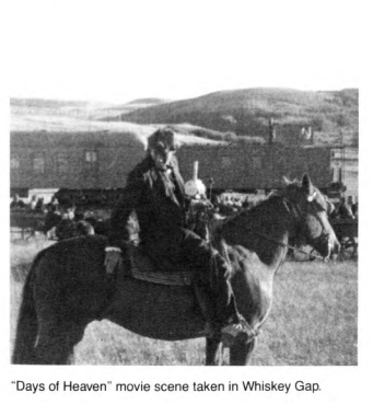
1977–1979: grain handling shifts to the roads
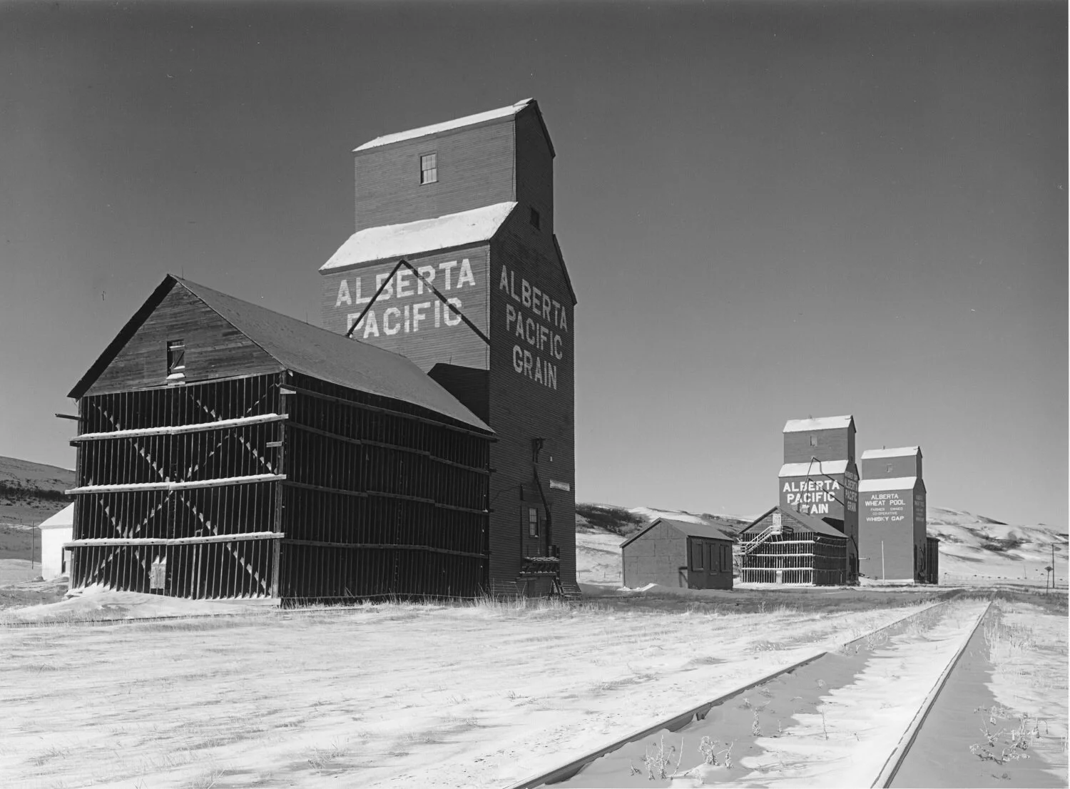
The federal Grain Handling and Transportation Commission described a small branch-line economy in 1977. Woolford and Whiskey Gap each had two Alberta Wheat Pool elevators. The four buildings dated from between 1923 and 1948, and the Pool said it did not intend to upgrade them. Across the entire subdivision, grain receipts averaged 402,000 bushels annually in the ten years ending in 1974–75. The commission identified alternative facilities at Cardston and Magrath and recommended abandoning the line on December 31, 1977. Grain and Rail in Western Canada, pp. 477–478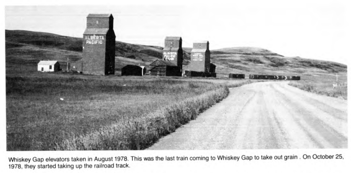
The grain-buying point closed in July 1978, according to Mr. Thompson’s subsequent report to Alberta’s legislature on June 15, 1979. Farmers, he said, now had to haul grain approximately thirty miles to an elevator. He reminded the government of its promise to improve secondary roads when the rail line closed and said he would pursue the matter with the transportation minister. Alberta Hansard, June 15, 1979, p. 384
February 1979: an elevator is dismantled
The community history records that elevator No. 2 was dismantled in February 1979. The other two elevators were retained for feed-grain storage. A separate photograph in the book shows an elevator blown down by wind after demolition had begun, although its caption does not identify the elevator or give the photograph’s date. Heritage of the High Country, pp. 34 and 49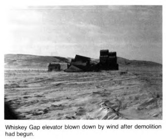
1983: elevators listed without railway service
The Canadian Grain Commission’s inventory for August 1, 1983, still listed two Alberta Wheat Pool primary elevators at Whiskey Gap. It placed them in its table of off-line elevators: facilities without a railway connection for shipping. The administrative record therefore continued to identify grain facilities at the site after the reported closure of the grain-buying point. Canadian Grain Commission, Grain Elevators in Canada, 1983–84 crop year, table 11, p. XXVI
2009: Huey Gum’s former inn in Del Bonita
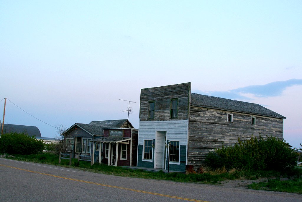
The former restaurant and lodging building associated with Huey Gum stands at the right. The building had been moved from Whiskey Gap to Del Bonita. Huey Gum and the inn
2011: buildings remembered in Del Bonita
The Galt Museum’s September 2011 article “Where Are They Now?” identified several Del Bonita buildings as having been brought from Whiskey Gap. Their continued use in Del Bonita preserved part of Whiskey Gap’s built history. The museum placed these moves within a wider southern Alberta practice of relocating houses, hotels, schools, teacherages and railway buildings for continued use. Galt Museum & Archives, “Where Are They Now?”, September 2011
Undated: Whiskey Gap in the community history book
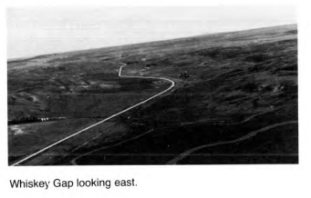
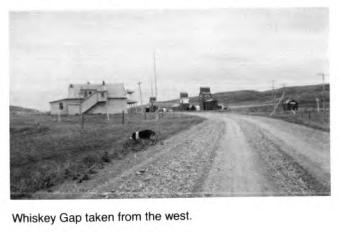
These three views appear in the Del Bonita Historical Society’s Heritage of the High Country (1981), pp. 46 and 48. Their printed captions identify the scenes without giving photograph dates.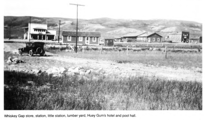
Huey Gum Inn · Del Bonita Post Office · Del Bonita history and photographs